Back

Geography


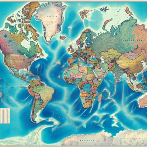
Studying the map of the world is crucial for several reasons. First, it enhances geographical literacy, enabling individuals to understand the location, size, and relationship between countries, continents, and oceans. This knowledge is vital for comprehending global events, trade, travel, and cultural exchanges. Second, it fosters global awareness and cultural sensitivity by highlighting the diversity of landscapes, climates, and societies. This awareness promotes empathy and cooperation in an increasingly interconnected world. Third, it aids in spatial thinking, helping individuals visualize and analyze spatial relationships and patterns, which are essential skills in various fields, such as urban planning, environmental science, and logistics. Lastly, it supports better decision-making in both personal and professional contexts, from planning trips to addressing global challenges like climate change and resource distribution. Overall, studying the world map cultivates informed, globally conscious citizens equipped to navigate and contribute to a complex world.

Atlas

Studying an atlas is important for year 3 kids because it helps them understand the world around them. An atlas introduces them to different countries, continents, and oceans, fostering a sense of global awareness. It aids in developing their spatial thinking skills as they learn to read maps and comprehend geographical locations. This foundational knowledge is essential for understanding other subjects like history, science, and social studies. Additionally, exploring an atlas can spark curiosity about different cultures and environments, encouraging children to appreciate diversity and interconnectedness. It also enhances their ability to follow directions and improves their general knowledge, which can be beneficial in everyday life. Overall, studying an atlas is a fun and educational way for young kids to start exploring the world beyond their immediate surroundings.

Use these cards to practice and learn how an atlas works. Click on the picture to access the cards.

Researching places in an atlas helps you learn more about different locations by providing detailed maps and information. An atlas shows the geography, climate, and major landmarks of each place, offering a visual understanding of the world’s layout. It helps you discover new countries, cities, and regions, and understand their relative positions. By studying an atlas, you can learn about the physical features, cultural aspects, and historical significance of various places. This knowledge broadens your perspective, enhances your geographic literacy, and fosters curiosity about the world around you.


Learning about North America is fascinating due to its diverse cultures, rich history, and varied landscapes. The continent includes Canada, the United States, and Mexico, each offering unique contributions to global culture and innovation. North America’s geography ranges from Arctic tundras to tropical beaches, illustrating the interplay between environment and human activity. Its history encompasses indigenous cultures, colonial periods, and modern developments, providing valuable insights into social evolution. Additionally, the continent’s economic influence and cultural diversity, with numerous languages, traditions, and cuisines, make it a vital area of study for understanding global dynamics and fostering intercultural appreciation.